10 MIN READ
|
5 FEBRUARY 2016
TOP 10 TRACKS: EXPLORE QUEENSTOWN BY FOOT WITH LUKE WELCH
Luke Welch's top ten places around Queenstown that can only be accessed with your own two feet - ranging from a simple afternoon stroll to a couple of multi-day adventures up in the remote hills.
Tagged under
Queenstown
Hiking
Tramping
New Zealand
Luke Welch
Growing up in the rolling hills and moors of Northumberland England, Luke Welch developed a deep love of the outdoors. From day walks and overnight camping trips as a kid, to devoting weekends to hiking, camping, and climbing as a teen, he eventually moved to Wales to become an outdoor instructor. During a camping trip in Snowdonia National Park in North Wales, a friend and colleague suggested a move further afield: New Zealand. At first the idea was brushed off, but now Luke Welch is an important part of The North Face Queenstown store, and an authority on exploring Queenstown by foot.
Whether you’re a Queenstown local, or have plans to visit the area, Luke has a list of must-do treks with his unique difficulty ratings ranging from ‘very tough’ to ‘easy as.’
PHOTOS AND WORDS BY LUKE WELCH
Queenstown is an extremely unique place. It is surrounded by an abundance of trails, crags and venues for literally any outdoor sport you could want to do. When visitors come in store and ask for recommendations on places to go, I can often get carried away.
I am going to share with you exactly what I tell them, my top ten places around Queenstown that can only be accessed with your own two feet - ranging from a simple afternoon stroll to a couple of multi-day adventures up in the remote hills.
1. BEN LOMOND | DAY TRIP | DIFFUCULTY: MODERATE

Let’s begin with a day hike. Starting from the centre of town, up to a summit with incredible views of the Southern Alps, Ben Lomond is the main big hill that looms over Queenstown, standing at 1748m tall. The easiest way to access the trail, especially without a car, is by the Tiki Trail which begins right next to the base building of the Skyline Gondola.
The Tiki Trail winds its way up through the pine forests of Bob’s Peak, crossing a few of the downhill mountain bike tracks on the way. Keep an eye out for adrenaline junkies on two wheels flying towards you. Eventually you will reach the tree line, emerging into a huge open space with the summit in full sight. From here, orange markers and signposts will guide you up a ridgeline to the Ben Lomond saddle, the low point between Ben Lomond itself and its neighbour, Bowen Peak.
The saddle is a great vantage point and good place to stop for a bite to eat before the final grunt to the summit. The steep section is ahead, following the well-established track you’ll zig zag up across the slopes and right around the side of the mountain to the summit. On a clear summer day, you could easily spend hours up there basking in the sun, enjoying the view. Return the same way back down to the saddle and on to the tree line, all the way back down to town for a well-deserved victory beer.
Note: There is no access to water after the Skyline building, so top up.
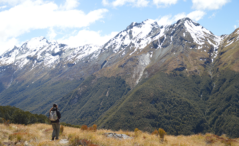
2. LAKE ALTA | HALF DAY | DIFFICULTY: EASY AS
Next up is a track at a higher altitude that leads to a fantastic alpine lake. This track begins at the base building of the Remarkables ski area. You will therefore require a vehicle, unless of course you fancy hiking up the 13km of road to get there.
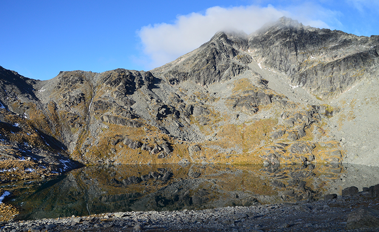
From the base building, there is a sign-posted road that will take you near the top of one of the ski lifts. Follow the road up for a short while until the track separates from the road and will lead away from the ski field over tussocky flats and multiple streams. After ascending for a short period you will reach the route’s main vantage point, which will reveal the lake.
Lake Alta lies in a huge bowl beneath the impressive summits of Single Cone and Double Cone. Continue down to the lake shore, and be amazed at the clarity of the water. On a fine day you will more than likely have many parties up there alongside you, many of which will be climbers with intentions of summiting the mountains via the various faces and ridges towering above.
3. THE GRAND TRAVERSE | ALPINE/MOUNTAINEERING DAY TRIP | DIFFICULTY: VERY TOUGH
 />
/>
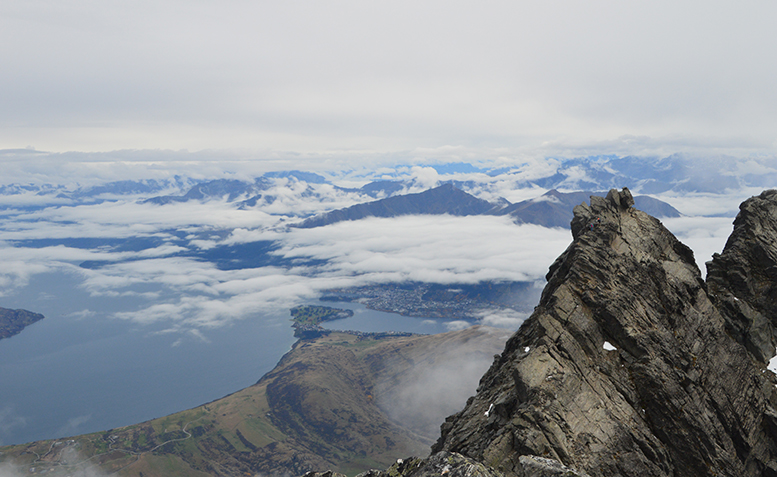
The Grand Traverse is considered one of Queenstown’s premier alpine routes. On this route, you’ll summit both peaks of Double Cone and the highest point of the Remarkables, Single Cone, which grants some of the best views down over Queenstown and in all directions. It can be done without any technical gear but parties will most likely carry a rope and all members will more than surely wear a helmet. There are not many easy escape routes from this traverse, so plenty of prior research is required to ensure that this is for you.
The Grand Traverse begins at Lake Alta, but soon leaves it far behind as you continue climbing up towards a point on the ridge to the right of the lake known as Telecom Tower, aptly named due to the antenna and radio equipment set up there. From Telecom Tower, traverse the ridge low on the lake side to avoid any difficulties before ascending towards Double Cone.
Careful route selection will be required here as this is considered the most difficult part of the traverse. You will soon top out on the false summit of Double Cone, followed by a drop in height and another climb to reach the true summit. Continue downwards to the top of what is known as the Grand Couloir, the main gully between Single Cone and Double Cone.
The final ascent is up to the summit of Single Cone, the climax of the entire route. From here there are a few descent options - the most used being either the North East or South East Ridges. At the southern point of the summit there is a bolted gully which, if you opted to carry technical gear and a 50/60m rope will be your quickest means of descending back to the South East Ridge. From the base of both of these routes you can then head back towards the lake, the saddle between Lake Alta and the head of Wye Creek being the easiest slope to move down. Once back at the lake, follow the track back to the car park. Time for a Fergburger!
4. WYE CREEK | HALF DAY (OR FULL DAY WITH CLIMBING) | DIFFICULTY: EASY

Wye Creek is hands down one of my absolute favourite places. It does well as a half day hike in itself, but the fact that it is probably Queenstown’s greatest climbing venue makes it an absolute must do whether you’re shooting up and back with a water bottle in hand or you’re hauling a full pack of gear up for the day ahead.
This track is accessed from a small car park on the side of Kingston Road, around a 15 minute drive from Frankton. A DOC signpost and a closed gate mark the access, so make sure you’re keeping an eye out as it can be easily passed when driving at 100km/hour. Follow the track up from the gate to a small grass clearing which is the car park. Note that the track does continue up the side of the hill to a smaller car park higher up but this is only suitable for 4WD vehicles capable of a steep climb.
From the higher car park, head over the stile past the installed toilet up the track. After around 20 minutes of climbing the track, you’ll come to an awesome little waterfall. A small sign will point the route out as continuing the climb but this isn’t the route I’m describing here. Instead of following the sign, carry on to the waterfall and cross over on the small walkway. The track will then continue out of the woods and join onto a water pipe with walking planks on top. Follow the pipeline and you’ll reach another waterfall, cross it and climb another few minutes to find yourself beneath the main wall of Wye Creek. The view back over to Queenstown from here is breathtaking, as is watching some of the climbers scuttling up the walls around you.
Note: The small sign at the first waterfall points you up to the full Wye Creek track. This is an 8 – 10 hour route that will climb the full creek right up to its origin at Lake Alta and the Remarkables Ski Field. This is a great route in itself but can be a pain to sort out transport at both ends.
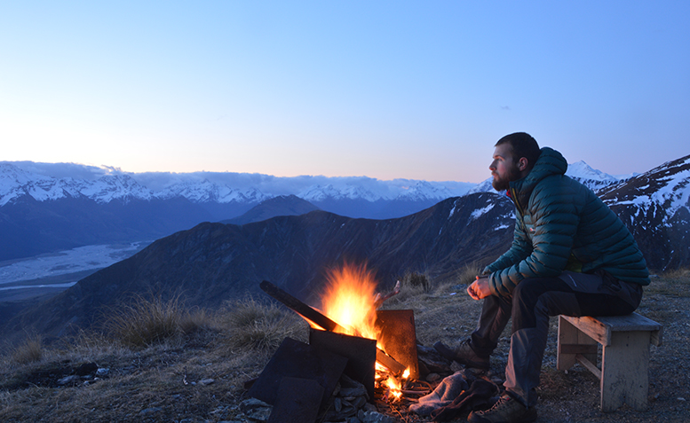
5. THE HEATHER JOCK HUT | DAY TRIP OR OVERNIGHT STAY | DIFFICULTY: FAIRLY EASY
The Heather Jock Hut is situated in the Whakaari Conservation Area. It is accessed from a small car park just before you enter the township of Glenorchy, around a 40 minute drive from Queenstown. It is a small three bunk ‘tin can on a ledge’ as I put it, sitting high on the flanks of Mt Alaska. The area is classified as a Conservation Area due to its rich history of scheelite mining activity, which is why there are still many huts remaining and also why you can expect to pass piles of old machine parts, cables and steel beams from a bygone era, rusted from years of lying dormant.
From the Whakaari car park, a small track will lead you up to join a gravel road which you’ll follow for the majority of this hike. Continue up the road which traverses high above the creek below, leading you round to a junction which will point left to the McIntosh and McIntyre huts on the other side of the creek.
For the Heather Jock hut, continue up the road until you reach another clear junction. This time both routes will lead you to the hut, as the whole hillside with the hut on it is one big loop track. I would recommend taking the left hand track down to a small river crossing followed by a long uphill zig zag track to the hut. On the way up you will pass the Bonnie Jean hut which has also been restored and is open to look inside but is not usable as an overnight hut.
After an hour or so of slogging uphill you will reach the Heather Jock hut. Take a break, pull the bench out and relax - that’s you done for the day. If you’ve only gone up as a day trip, well - you’ll wish you were staying there the night. Enjoy the views back down to the Dart River, and make sure to sign the guestbook. From here you can either descend back down the same route or continue around the loop track down to the road.
Note: This hut has a long drop toilet and a water tank on site. There is also plenty of flat ground around it for camping in the event of the hut already being in use by another party.
6. BLACK PEAK AND THE MCINTOSH HUT LOOP TRACK | OVERNIGHTER | DIFFICULTY: MORE DIFFICULT
The McIntosh Hut is another of the Whakaari Conservation Area mining huts sitting a lot higher up on the side of Mt McIntosh at around 1460m. This one is much larger than the Heather Jock Hut accommodating up to 6 people, with a long drop toilet, water tank, a kitchen area and dining tables too.
To reach this hut, follow the description as for the Heather Jock Hut, however upon reaching the DOC signposted junction you will head left travelling downhill towards the creek. This is an actual river crossing and the creek level can vary at any time of year so experience and confidence will be necessary here. If in doubt, don’t cross.
Once across the creek, the track picks up heading uphill through the bush and out onto the slopes. After around 45 minutes of an uphill zig zag, you’ll reach the McIntyre hut which would also make a good alternative accommodation for the night. To continue on, head up the clear cut track for another hour or so until you reach the Long Gully Saddle. From here you have two choices. You can either turn left and continue up and over the ridgeline following the loop track or turn right which will lead you further uphill where you will find the McIntosh hut. This hut offers incredible views down over the Dart and Rees Rivers, Mt Alfred and Otago’s tallest mountain – Mt Earnslaw.
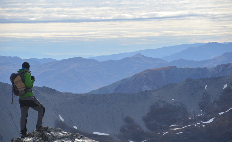
If you have opted to include Black Peak in your trip, I’d recommend an early start the next morning to head up there. Black Peak is accessed by returning down to the track that lead you up to the hut. Another clear cut track that is not marked leads away to the East. After following this track, even for around 20 minutes, Black Peak will reveal itself to you as it stands at 1986m tall.
Following this old bulldozer track will lead you up to near the summit of the peak, however the last section is an untracked, unmarked scramble on loose schist scree which will require good hand and foot placements. There may well still be snow up here too, depending on how late in the season you head up. After a few false summits in the form of rock columns, you will eventually find yourself on the highest point, looking down into the Buckler Burn and along the sharp knife edge ridgeline leading away Eastwards. Descend back down the slopes to regain the track back to the hut.
Heading back down the junction on the ridgeline, you will now re-join the loop track and head up over the ridge to begin descending the other side. There are clear markers along the side of a fence to guide you down the steep grassy slope into the Buckler burn, but the track itself is mostly unformed so you will have to rely on tussock for solid foot placements here. The slope seems to go on forever but eventually you will find yourself passing through a few sheep fields, and along the side of a small canal which will take you back to the Glenorchy road, only around a ten minute walk from your car.
Rough timings for this track are as follows:
Car Park – McIntosh Hut: Around 4 hours
McIntosh Hut – Black Peak Return: Around 3 hours
McIntosh Hut – Glenorchy Road: 4 – 5 hours
McIntosh Loop Track without detour to McIntosh Hut: 8 – 10 hours
Loop Including Black Peak: 12 – 14 hours
7. MOUNT ALFRED | DAY TRIP | DIFFICULTY: MODERATE

Mt Alfred is an awesome day walk with 360 degree views of mountains, glaciers, rivers and Lake Wakatipu. It is the big wedge shaped hill with a spinal ridge that divides the Dart and Rees rivers north of Glenorchy.
The start of this track is located at the base of the western slope of the mountain, therefore you will need to drive up through Glenorchy. Follow signposts for the Routeburn track, but once you are travelling north with the mountain on your right hand side you will have to keep a close eye out as the car park is not very clearly marked. You are looking for a small stile with an orange triangle on it with space for 4 or 5 cars next to it.
Once you have found the car park, head over the stile up into the woods. The track ascends through the beech trees steadily, but it will gradually get steeper. The orange markers will guide you up, but make sure you’re keeping an eye out as many of them are on trees that may have fallen since their placement. After around 2 hours you will reach the bush line and a DOC sign, which will reveal the open steep slopes. The track from here ascends a sort of gully up to the ridge, most of which is very steep and will require focus on where you’re putting your hands and feet - especially with many speargrass plants sitting on ledges the whole way up. You will know if you’ve touched it – the name says it all.
Once you reach the ridge, head north along the spine of the mountain to reach the true summit marked by a mast with a traffic cone on top of it. Here you will see the Humboldt Mountains to the west, the Richardson’s to the East, Mt Earnslaw and the Routeburn mountains to the North and Lake Wakatipu to the South.
After a lunch stop and a final admiration of the views, descend the same way back down to the bush line and on downwards through the forests to the car park. There is no shelter on this track above the bush, so remember to take spare layers as the exposed top can be windy. Water can be taken from the small creeks on the way up.
8. SUGERLOAF PASS | DAY TRIP | DIFFICULTY: MODERATE
Sugarloaf Pass is situated above the Routeburn and Rockburn valleys on the edge of Mt Aspiring National Park, connecting the two. The Routeburn is famous for its Great Walk track making it very easy to access, however the Rockburn has no formed track and so once accessed will feel much more remote. Sugarloaf Pass can be accessed easily from the Routeburn track itself, so parking is at the Routeburn Road end shelter, around 1 hr 20 drive from Queenstown via Glenorchy. It is very well signposted from the Glenorchy Township.
From the Routeburn car park, begin on the Great Walk track from the swing bridge as you would if you were walking the whole track. Around 20 minutes into the track, you will reach a DOC signpost that clearly informs that the Sugarloaf Pass track is not part of the Routeburn itself. Take the turn off from here and begin to follow orange markers up through the beech forest.
Once you emerge from the bushline you will find yourself on an open tussocky plane with the track clearly marked. Much of this will be soggy so be careful where you’re treading. Soon after you will reach a point where the Rockburn Valley will be visible. From here you can ascend the slopes either side of you to find a good ledge or rocky outcrop for lunch and gain a higher vantage point of the two valleys and the western faces of Mt Earnslaw. The track does continue down the other side into the Rockburn valley, however the day trip I am describing here stops at the highest point of the pass.
Descend the same way you came, back down to the Routeburn track and out to the car park.
9. THE EARNSLAW BURN | OVERNIGHT | DIFFICULTY: MORE DIFFICULT
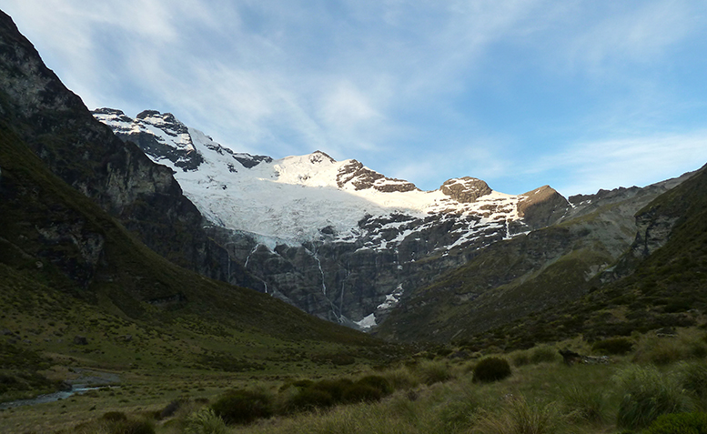
This overnight trip includes probably the best place I’ve ever pitched a tent. You will camp out beneath the Earnslaw Glacier, below the two intimidating summits of Mt Earnslaw. As you sit and take in the surroundings, don’t be at all surprised if you witness huge chunks of ice break off from the glacier and hurtle down the ice cliffs into the head of the burn below with a thunderous roar. It is an incredible event to be able to sit and watch right from your front porch.
From Glenorchy, continue driving North to where the sealed road will turn off heading towards Mt Alfred and the Routeburn track, and a gravel road will continue towards Paradise – yes, it’s actually called Paradise. Continue along the gravel road for about 10 minutes, and a road signposted as Lover’s Leap Road will take you off the main Paradise Road. By now Mt Earnslaw should be towering above you and the valley of the Earnslaw Burn will be staring you in the face. A DOC signpost will signal the start of the track, just after an obvious right bend in the road. Pull off here and make sure you park your car well clear of the road as it is active farmland access.
The track will be marked by orange triangles, but just like all other tracks through Beech forest these can be few and far between with some existing on fallen trees. This track is not obvious in a lot of places so a careful lookout for the markers will be needed. You will climb over and under many obstacles along this route, which is why it will take longer than you’d think a track of its length would.
After roughly 4 hours you will leave the bushline. From here, a well-established rock bivouac has been created across the river which is clearly marked and signposted however you will have to make a river crossing if you wish to stay here. Personally, I’d recommend ignoring the rock bivouac as it is still quite a distance from the end of the Burn, and the glacier itself. I would recommend continuing into the Burn, there is no markers but a very faint track from the footfall of others will keep you on the right lines. After another 30 – 40 minutes from the rock bivi turn off, you will find an open flat area next to the river which makes for a perfect campsite. The views of the glacier and surrounding faces from here are phenomenal, and you will fully realise why it is one of my favourite places to camp out. Buckle down and enjoy the night, while listening to the cracks and roars from the glacier throughout the night.
The next morning, leave the campsite early and head towards the glacier face for a front row seat of the first rays of sunlight hitting the ice face. This will very quickly warm up the ice, so early morning is the best time of day to catch some of the action.
10. THE MOUNT CRICHTON LOOP TRACK | HALF DAY | DIFFICULTY: EASY
![Mt Crichton Loop src=]()
Last of all, I thought I’d go for a popular loop track close to Queenstown which details the history of the area and the life of one particular man very well. The Mt Crichton Loop Track starts from a small well-signposted car park around 20 minutes’ drive from Queenstown along the Glenorchy Road.
This is a very well-marked and formed track the whole way round, so you will never have a problem following it. On the route you will pass many old pieces of equipment from the mining period, but the highlight of the trip is the Sam Summers hut. This spectacular gentleman built his own hut out here in the woods next to the creek, including walls, a toilet and a fireplace too. I won’t disclose too much more information about Sam Summers himself or the hut, you’ll have to head out there to find out more. I like this track a lot, as it’s a great place to walk or run, and it’s very connected to the roots of this region. Many of the local schools and scout groups use this track as an active and educational trip for the classes.
If you plan on attempting any of these routes in Spring, Autumn and Winter, carefully check the weather forecast, snow conditions and avalanche forecast where needed, with particular reference to the Grand Traverse and higher altitude routes. Weather can change at any time of year in New Zealand, snow can even fall in peak Summer so it is essential to make the required preparations.
If in doubt, head in store to The North Face Queenstown, where Luke or one of the team there will be able to offer a host of advice and ideas for your adventures in Queenstown. Find us at: 36/38 Shotover St, Queenstown.
Keep up to date with The North Face athletes, news and events through our Facebook page, Instagram and YouTube Channel.